Review map of transmitters
This is basic map to get review of transmitters. The transmitters without any channel are included too. To show map go to menu item: Maps ->Review map.
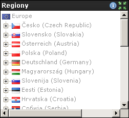 On right side is tree menu. Choose region name to show only transmitters in selected region. So you can show all transmitters, for selected country, region, sub region or selected transmitter. Map zoom is automatically changed to maximalize view. This way you can get very simply review of transmitters in selected area.
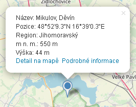 Move cursor over transmitter icon to get name and position. For example, transmitter Pavlov, Děvín is showed Česko->Jihomoravský->Břeclav->Pavlov, Děvín. After click the window with basic information is showed. See picture on left side. Use link Detail on map to show detailed information. Automatically is displayed maximalized information window. In this mode you can see altitude, height and transmitted channels. You can work with map as you know form classic Google map.
Tip: if you want show map for country just append ? and country code. Example: /muxglobal.html?cz shows transmitters for Czech Republic, /muxglobal.html?at for Austria. In present you can use these codes: cz, sk, at, pl, de, hu, si, ee, hr, rs, lt, lv, ua, nl, ch, ro, it, fr, be, lu, bg, ba, me, ie, dk, gb, se, no, fi, by, ge, pt and md.
Distance and terrain profile

 This map is intended to show selected transmitters to defined position. First step is to define your position on map. Search position by map controls and mouse wheel then use double click to create your position green mark. To fines specification of position use satellite map and drag and drop on icon. At the lower left corner is control to display your position in WGS 84 format with altitude (meters). Here you can set up antenna height above ground by drag or click on value indicator. The antenna height is use by terrain profile generator.
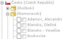
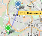 Now use tree menu to define transmitters. Every transmitter's name has checkbox. Check it and automatically is created line between your defined position and selected(checked) transmitter. This line helps you imagine way to transmitter. Your icon has now information window. To show window, click on green icon. Window contains transmitter name, distance, azimuth and link to show terrain profile.
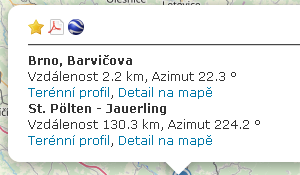 For bookamark map use star icon. Due to different implementations the message window with hint how to create bookmark in browser is displayed. You can put bookmark's URL to forum or to your friends. If count of transmitters is less or equal to 10, information window contain link to generate PDF export. You can get report example here. Report contains information about your defined position, altitude and selected transmitters with their position. Every transmitter has table with defined channel for record measured values and terrain profile.
Terrain profile has direction from trasmitter to defined position. Number of selected transmitters has no restriction and you can still change your position. Map is automatically changed. To refresh terrain profile you must click on link in information window.

Mux map
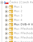 This map is similar to review map. But map shows only transmitters that have defined at least one mux. To show map go to menu item Maps ->Mux map. Other functionality is same as for review map.
Tree menu on right side is supplemented by list of muxes for selected country. Under selected mux are only regions with transmitters with selected mux. For show items only for defined mux select the name of region or area.
Tip: if you want show map with muxes for country just appent ? and country code. Example: /muxglobal?cz shos transmitters for Czech Republic, /muxglobal?at for Austria. In present you can use these codes: cz, sk, at, pl, hu and de. Next you can specify mux by adding mux name to URL. Add char "-" and mux name without spaces. Example: for first Austria mux A (MUX A) will be url /mapmux.html?at-muxa, for second Austria mux (MUX B) /mapmux.html?at-muxb etc.
Map of nearest transmitters
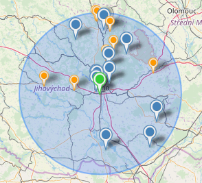 Map is similar to terrain and profile map. Difference is in way how transmitters are displayed. First step is to define your position. It's same as for distance and profile map.
 When position is defined, automatically are showed transmitters that accept condition of distance. Distance must be less or equal than defined. You can change it by scroll bar. The area is displayed as circle with blue background. Currently your icon has information window with same information about transmitters as distance and terrain map.
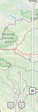
The controls to reduce showed transmitters by channel, ERP and distance are placed at the right bottom corner. Drag value indicator to set up required value or just click to increment value by 1. Set up lowest value for channel and/or ERP to deactivate controls.
Two points terrain map

 This map allow you to get terrain profile between two arbitrary points. To defined points use double click on map. You can redefine points position by double click on map or drag and drop action. The points are connected by light blue line. Every point contains these informations: distance, azimuth to next point and link to generate terrain profile. To show info window click on defined point A or point B.
 Terrain window contains, as previous maps, icons for modify generated terrain profile.
Coverage map
 Coverage map visualize theoretical signal level for selected transmitter with channel. You can get coverage map only for transmitter with channel. The example coverage map is displayed on left side. Picture on right side shows component for change opacity for coverage signal.

 Signal level is rated for antenna gain 10dBd (12,15 dBi) with circular diagram above ground 2m. For pasive component was added loss 6dB (cabel, connector). The signal level is default displayed in dBμV. Click on color scale for change signal level to dBm.
Warning
Every map uses cookies to store properties of maps. Map will be automatically restored to state before you leave it.
Markers
 - transmitter with power more than 5kW
 - transmitter with power more than 5kW with coverage map
 - transmitter with power less than 5kW with coverage map
 - transmitter with power more than 5kW without coverage map
 - transmitter with power less than 5kW without coverage map
 - waiting for approving